Log in
All resources
Create a design
298 Free Artworks of 1880s Maps
maps from the earth and its inhabitants, vol. iv
guides joanne
algeria in the 1880s
maps of paris from paris musées
maps of paris by paul dujardin
atlas des anciens plans de paris by imprimerie nationale, 1880 from the musée carnavalet
musée carnavalet
atlas des anciens plans de paris by imprimerie nationale, 1880 from bhvp
old maps of algeria
maps from the earth and its inhabitants, vol. x
algeria in the 1880s
old maps of algeria
historisk atlas (stockholm, norstedt & söner, 1880)
maps of 11th-century italy
maps of luzy (nièvre)
amédée jullien
19th-century maps of chechnya
1880s maps of the caucasus
montgomery, alabama in the 1880s
maps in the library of congress
1880s maps of the netherlands
1880s maps of belgium
maps in the library of congress
old maps of anniston, alabama
algeria in the 1880s
old maps of oran
maps from the earth and its inhabitants, vol. iv
bathymetric maps of the united kingdom
rudolf leuzinger
maps of france
turgot map of paris, musée carnavalet
maps of paris from paris musées
turgot map of paris, musée carnavalet
maps of paris from paris musées
turgot map of paris, musée carnavalet
maps of paris from paris musées
maps, prints and photographs in royal danish library
casinoteatret
baumwollspinnerei im sood
fabrikkanal sihltal
maps from the earth and its inhabitants, vol. iv
geological maps of the united kingdom
maps from gallica
old maps of genoa
the story of mexico (1889 book)
1880s maps of mexico
maps by jan eduard wagner
františek kytka
19th-century maps of bohemia
1880s maps of czechia
maps from the earth and its inhabitants, vol. x
19th-century maps of cairo
maps in the library of congress
1880s maps of new hampshire
algeria in the 1880s
old maps of algeria
maps from the earth and its inhabitants, vol. iv
1880s maps of england
maps of paris from paris musées
plan de turgot
atlas des anciens plans de paris by imprimerie nationale, 1880 from the musée carnavalet
maps of paris from paris musées
maps from the earth and its inhabitants, vol. x
1880s maps of egypt
dr. wilh. junker's reisen in afrika 1875-1886
1880s maps of sudan
maps from the earth and its inhabitants, vol. v
maps of skaftafell
admiralty charts region b: england wales ireland english channel southern north sea
admiralty charts 1401-1600
historisk atlas (stockholm, norstedt & söner, 1880)
old maps of the roman empire
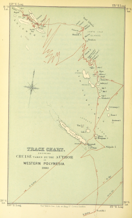
the cruise of the marchesa (1889)
1880s maps of the philippines
with the armies of the balkans and at gallipoli (1880)
battle of gallipoli
algiers in the 1880s
old maps of algiers
drawings in the stadsarchief amsterdam
johan martinus anthon rieke
atlas des anciens plans de paris by imprimerie nationale, 1880 from the musée carnavalet
maps of paris from paris musées
maps from the earth and its inhabitants, vol. xi
africa in the 1880s
maps from the earth and its inhabitants, vol. xi
africa in the 1880s
maps from the earth and its inhabitants, vol. iv
1880s maps of ireland
algeria in the 1880s
old maps of algeria
algeria in the 1880s
old maps of algeria
maps in the library of congress
1882 maps of new york (state)
maps from the earth and its inhabitants, vol. xii
africa in the 1890s
maps from the earth and its inhabitants, vol. xi
africa in the 1880s
maps from the earth and its inhabitants, vol. xi
africa in the 1880s
maps from the earth and its inhabitants, vol. iv
turlough
with the armies of the balkans and at gallipoli (1880)
maps of the military history of bulgaria
maps from the earth and its inhabitants, vol. iv
kingsmead, bath
maps from the earth and its inhabitants, vol. iii
old maps of bonn
lithographs of paris
floor plans of paris
maps from the earth and its inhabitants, vol. x
1880s maps of egypt
maps from the earth and its inhabitants, vol. x
1880s maps of egypt
maps from the earth and its inhabitants, vol. iv
1880s maps of london
atlas des anciens plans de paris by imprimerie nationale, 1880 from the musée carnavalet
maps of paris from paris musées
norwegian north-atlantic expedition (1876-1878)
old maps of jan mayen
maps in the rijksmuseum amsterdam
emrik & binger
maps of paris from paris musées
baroque
dr. wilh. junker's reisen in afrika 1875-1886
1889 maps of sudan
maps from the earth and its inhabitants, vol. iv
1880s maps of ireland
algeria in the 1880s
old maps of algeria
algeria in the 1880s
old maps of algeria
maps from the earth and its inhabitants, vol. iv
mount merrick
1860s maps of china
1863 maps of asia
wanderings, south and east (1882)
old maps of polynesia
atlas des anciens plans de paris by imprimerie nationale, 1880 from bhvp
maps of paris by braun & hogenberg
maps from the earth and its inhabitants, vol. v
1880s maps of iceland
maps from the earth and its inhabitants, vol. x
kassala
thomas robert macquoid
maps of the ardennes
maps from the earth and its inhabitants, vol. v
19th-century maps of scandinavia
maps from the earth and its inhabitants, vol. iv
1880s maps of london
maps in the rijksmuseum amsterdam
paintings of venice
the cruise of the marchesa (1889)
19th-century maps of borneo
everett d. graff collection of western americana
maps of the indian territory
maps from the earth and its inhabitants, vol. iv
1880s maps of the british isles
maps from the earth and its inhabitants, vol. iv
1880s maps of london
maps from the earth and its inhabitants, vol. iv
1880s maps of the atlantic ocean
atlas des anciens plans de paris by imprimerie nationale, 1880 from bhvp
map of paris by jouvin de rochefort (boutier 112)
the cruise of the marchesa (1889)
19th-century maps of new guinea
1880s maps of south africa
emil holub
maps from the earth and its inhabitants, vol. iv
faversham creek
maps from the earth and its inhabitants, vol. iv
ragstone
atlas des anciens plans de paris by imprimerie nationale, 1880 from bhvp
map of paris by jouvin de rochefort (boutier 112)
atlas des anciens plans de paris by imprimerie nationale, 1880 from bhvp
18th-century maps of paris
atlas des anciens plans de paris by imprimerie nationale, 1880 from bhvp
map of paris by jouvin de rochefort (boutier 112)
algeria in the 1880s
mascara, algeria
atlas des anciens plans de paris by imprimerie nationale, 1880 from bhvp
proletarian literature
maps from the earth and its inhabitants, vol. iv
ragstone
maps from the earth and its inhabitants, vol. iv
amesbury
illustrations from découverte de la terre
jacques cartier by théophile hamel
maps from the earth and its inhabitants, vol. iv
19th-century maps of surrey
maps from the earth and its inhabitants, vol. iv
maps of penzance
maps from the earth and its inhabitants, vol. iv
old maps of cardiff
maps from the earth and its inhabitants, vol. x
1886 maps of africa
maps from the earth and its inhabitants, vol. iv
maps of balmoral castle
maps from the earth and its inhabitants, vol. iv
maritime maps of the united kingdom
pedro álvares cabral in art
discovery of brazil
maps from the earth and its inhabitants, vol. iv
maps of balmoral castle
maps from the earth and its inhabitants, vol. iv
old maps of hastings, england
la palestine (1883, by chardin)
travel maps of palestine
atlas des anciens plans de paris by imprimerie nationale, 1880 from bhvp
map of paris by françois quesnel
101 - 200 of 298
Next page
/ 3